
 K1VV and N1DT plan to activate East Chop (USA 259) and West Chop (USA 877) Lighthouses on Martha’s Vineyard Island on Saturday May 12, 2007 from 7:00 AM EDT (1130 UTC) until about 2:00 PM EDT (1400 UTC).
Whitey, K1VV notes that he and Don, N1DT will begin operations on 75 meters around 3996 kHz plus/minus 5 kHz. On 40 phone, look for W1AA between the nets. “Tune for us between the nets, most likely around 7234,” writes K1VV. They’ll be on 20 phone later in the morning above 14310, or 17 meters above 18150. “We will return to 40 phone about 1530 to 1600 UTC, about noon local time.”
Morse code operation will be conducted roughly on the half hour, on 7035, 10116, 14035 and 18080 kHz, plus or minus QRM.
“We should be able to access the RF packet node so we will be posting our spots on the DX Summit. But we would appreciate any spots,” Whitey adds. See http://oh2aq.kolumbus.com/dxs/hfdx25.html .
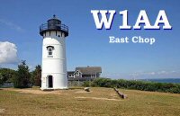
DX QSLs are via the W1 Bureau and stateside are via W1AA please with an SASE. A photo of the lighthouse will be furnished. “Remember that the postal rates change on May 14, 2007. So make sure you have enough postage on your SASE,” writes K1VV.
The first lighthouse at West Chop was a 25-foot stone tower built in 1817 for $5000. In 1976, West Chop Light became automated. The original Fresnel lens is still in the lantern room. Today the active aid to navigation exhibits its white flash, visible for 15 miles. A red sector in the lens warns mariners away from two dangerous shoals.
The lighthouse and grounds are not open to the public, but you can easily view the station from West Chop Road or the ferries in and out of Vineyard Haven.
–Thanks, K1VV and Keep The Lights Shining