ARRL Approves Framingham ARA Flea Market

Framingham ARA logoARRL Headquarters gave the Framingham ARA the “thumbs-up” for its spring flea market.

In a letter dated January 29, 2004 to FARA’s Beverly Lees, N1LOO, ARRL Convention Program Manager Gail Iannone wrote, “We’re pleased to tell you that Director Frenaye has approved the application of the Framingham Amateur Radio Association to hold an ARRL approved hamfest in Framingham, MA on March 28, 2004.”

FARA’s flea market is held bi-annually. The March 28 event will be from 9:00 a.m. to 1:00 p.m. at the Walsh Middle School in Framingham. For further details, check the Framingham ARA website at http://www.fara.org.

Licensing Restructuring: “The Real Deal”

ARRL flag
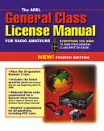
On January 19, 2004 the ARRL Board of Directors voted to request that FCC amend Part 97 to restructure the Amateur Radio Service and to introduce a new entry-level “Novice” code-free license with HF privileges (see ARRL to Propose New Entry-Level License, Code-Free HF Access).

ARRL Headquarters has produced an excellent Frequently Asked Questions document that answers your questions about restructuring and explains the rationale behind the League’s request.

Please take a moment and review this material. When the period for comment arrives, I would encourage everyone to voice their views–pro or con—on this important issue. -K9HI

Winter Exercise Invitation

New EMA ARES On behalf of all the Eastern Massachusetts (EMa) DEC’s and EC’s, I would like to extend a cordial invitation to play in our annual Winter Communications Exercise, scheduled for Saturday February 21st. As most of you know, we are entering our “Nor’easter” season, so it is our annual opportunity to formally evaluate our winter emergency communication skills and readiness. This message will be the first in a series of messages about the exercise.

The goal of the exercise is to respond effectively to a storm driven massive power outage affecting the entire section. Among various objectives that will be emphasized include local response with an inter-district communication element. Please contact your DEC to coordinate your efforts on this year’s exercise.

The ARES Leadership is reminded to keep a detailed roster and/or logs of those stations participating in the exercise.

s/Michael P. Neilsen
Michael P. Neilsen, W1MPN
Section Emergency Coordinator
Eastern Massachusetts Section

CCARES Drill

EMa ARES Logo CCARES will hold its “Operation Big Chill” exercise this Saturday, 31 Jan at 1000 throughout the Cape and Islands District.

[The following article contributed by K9HI at http://ema.arrl.org/article.php?sid=319 , -W1MPN]

Grab your boots and mittens—oh, and your Go-kit for the Cape Cod Amateur Radio Emergency Service’s (CCARES) winter cold weather exercise on January 31, 2004 beginning at 9:00 a.m. Dubbed “Operation Arctic Chill” the exercise will test the ability of Emergency Operation Centers, zone-based relay stations, and field operations teams under freeezing, weather conditions.

WQ1O “This will be a drill to test our primary stations and other ARES member home stations,” explained District Emergency Coordinator Frank O’Laughlin, WQ1O. “We will attempt to utilize HF NVIS, VHF/UHF simplex FM. We’ll also utilize VHF/UHF SSB and digital modes. And we will attempt communications with other ARES districts and their EOCs.”

WQ1O Photo courtesy of K9HI

Storm Coor Msg #6 (expired)

SKYWARN Logo Hello to all…

….Due to Dry Air, a Storm System Track Further South Than Expected, and
the Storm System Not Being Captured By the Upper Level Low Pressure System,
Less Snowfall Than Expected Across Much of Southern New England with the
Hardest Hit Area Being CT, RI and Southeast Massachusetts including Cape Cod
and Islands….
….Winter WX Advisory Has Been Posted for South Coastal Massachusetts and
Rhode Island Including Cape Cod and the Islands where total snowfall will
range from 3-6″….
…Storm Totals Have Ranged from 2-4″ over portions of Southeast
Massachusetts and Rhode Island to 3-5″ in the Springfield area to 4-9″ in
Connecticut…
…SKYWARN Self-Activation Will Not Occur But Please Report Snowfall Every
2″ and Final Amounts to NWS Taunton….

The storm system that was slated to impact much of Southern New England
trended further and further south with each successive model run. In
addition, dry air over much of Northeast Massachusetts and Southern New
Hampshire prevented any type of heavy precipitation to make a northward
advance on this region so no snow occurred.

A Winter WX Advisory Has Been Posted for South Coastal Massachusetts and
Rhode Island and Cape Cod and the Islands where total storm accumilations of
3-6″ will occur.

This will be the last message on this situation. Below is the Winter WX
Advisory Statement and the Public Information Statement concerning snowfall
so far from this event:WWUS41 KBOX 281235
WSWBOX

URGENT – WINTER WEATHER MESSAGE
NATIONAL WEATHER SERVICE TAUNTON MA
735 AM EST WED JAN 28 2004

MAZ020>024-RIZ005>008-281700-
BARNSTABLE MA-BLOCK ISLAND RI-BRISTOL RI-DUKES MA-NANTUCKET MA-
NEWPORT RI-SOUTHERN BRISTOL MA-SOUTHERN PLYMOUTH MA-WASHINGTON RI-
735 AM EST WED JAN 28 2004

…WINTER WEATHER ADVISORY THIS MORNING FOR SOUTH COASTAL RHODE
ISLAND AND MASSACHUSETTS…

SNOW WILL TAPER OFF TO SCATTERED SNOW SHOWERS THIS AFTERNOON…GIVING
TOTAL ACCUMULATIONS OF 3 TO 6 INCHES.

THE SNOW WILL MAKE ROADWAYS SLICK…SO MOTORISTS ARE URGED TO DRIVE
WITH CAUTION. PAY ATTENTION TO CHANGING ROAD CONDITIONS. SLOW DOWN…
AND ALLOW EXTRA TIME TO REACH YOUR DESTINATION.

$$

JWD

NOUS41 KBOX 281236
PNSBOX

PUBLIC INFORMATION STATEMENT
NATIONAL WEATHER SERVICE TAUNTON MA
735 AM EST WED JAN 28 2004

…SNOWFALL REPORTS FROM JANUARY 27TH-28TH…

THE FOLLOWING IS A REPRESENTATIVE SUMMARY OF SNOW REPORTS FOR THE
SNOWFALL WHICH BEGAN TUESDAY EVENING AND CONTINUED THROUGH WEDENSDAY
MORING.

THANKS TO COOPERATIVE OBSERVERS AND SKYWARN SPOTTERS FOR YOUR HELP.

THIS SUMMARY IS ALSO AVAILABLE ON OUR HOME PAGE AT
(SMALL LETTERS) HTTP://WWW.NWS.NOAA.GOV/ER/BOX

STORM COMMENTS
LOCATION TOTAL

…CONNECTICUT…

…HARTFORD COUNTY…
SOUTH WINDSOR 8.5
FARMINGTON 8.0
MANCHESTER 7.0 6:15 AM
WETHERSFIELD 6.5
BURLINGTON 6.5 6:00 AM
GLASTONBURY 6.0
SUFFIELD 5.5 5:15 AM
EAST GRANBY 5.0

…TOLLAND COUNTY…
MANSFIELD HOLLOW LAKE 6.0 7:15 AM COOP
UNION 6.0
VERNON 5.8
MANSFIELD 5.5
STAFFORD SPRINGS 4.6 7:15 AM COOP

…WINDHAM COUNTY…
POMFRET 6.0 7:25 AM
PUTNAM 4.0

…MASSACHUSETTS…

…BARNSTABLE COUNTY…
FALMOUTH 3.0 6:45 AM

…BRISTOL…

…DUKES COUNTY…
MARTHAS VINEYARD 2.5 6:25 AM

…ESSEX COUNTY…

…FRANKLIN COUNTY…
LEVERETT 6.5 7:30 AM
SHELBURNE 2.5 6:50 AM

…HAMPDEN COUNTY…
FEEDING HILLS 4.5 5:15 AM
MONTGOMERY 4.0 6:30 AM
SPRINGFIELD 4.0 4:45 AM
WESTFIELD 3.5 4:45 AM
WEST HOLYOKE 3.0 4:45 AM

…HAMPSHIRE COUNTY…
NORTHAMPTON 2.5 4:45 AM

…MIDDLESEX COUNTY…

…NANTUCKET COUNTY…
NANTUCKET 4.0 7:15 AM

…NORFOLK COUNTY…

…PLYMOUTH COUNTY…

…SUFFOLK COUNTY…

…WORCESTER COUNTY…
WORCESTER AIRPORT 1.4

…RHODE ISLAND…

…KENT COUNTY…
WEST WARWICK 3.0 7:20 AM

…NEWPORT COUNTY…
LITTLE COMPTON 3.0 6:45 AM

…PROVIDENCE COUNTY…
NORTH FOSTER 4.0 7:10 AM
JOHNSTON 3.0 6:25 AM
BURRILLVILLE 2.5 6:50 AM

…WASHINGTON COUNTY…

$$
AED

Respectfully Submitted,

Robert Macedo (KD1CY)
ARES SKYWARN Coordinator
Southeast Massachusetts ARES District Emergency Coordinator
SEMARA ARES Emergency Coordinator
Pager #: (508) 354-3142
Home Phone #: (508) 994-1875 (After 6 PM)
Home/Data #: (508) 997-4503 (After 6 PM)
Work Phone #: 1-800-445-2588 Ext.: 72929 (8 AM-5 PM)
Email Address: rmacedo@rcn.com
http://users.rcn.com/rmacedo

ARECC Exams Offered

ARECC Logo From: Telsey, Steven
Sent: Tuesday, January 27, 2004 12:26 PM

Subject: ARECC Exams Offered

The Eastern Massachusetts Section ARES is sponsoring an ARECC exam session:

Date: Saturday, February 28, 10:00am

Location: State Emergency Operations Center (MEMA HQ)
400 Worcester Road(Route 9 eastbound), Framingham, MA 01702-5399
(508)-820-1428

Directions: See
http://www.mass.gov/agency/documents/mema/MEMA_Headquarters_Directions.doc.

Note: This is a secure facility. Pre-registration by Monday, February 23 is required. Please contact Mike Neilsen at w1mpn@ema.arrl.org. You must bring a photo ID to be admitted.

Exams Offered: Exams for Levels I-III will be offered.

Exam Format: Multiple choice. Open-book, but no collaboration
permitted.

Cost: The cost is $10.00 per exam, $30.00 to take all three levels. You may retake a level once if necessary without additional cost if you do not pass with 80% or better. 73,

Exam Coordinator: Steve Telsey, N1BDA
40 Pine St.
Concord, MA 01742
978-369-7366 Evenings
n1bda@arrl.net

CCARES “Operation Arctic Chill” January 31, 2004

EMA ARES logoGrab your boots and mittens—oh, and your Go-kit for the Cape Cod Amateur Radio Emergency Service’s (CCARES) winter cold weather exercise on January 31, 2004 beginning at 9:00 a.m. Dubbed “Operation Arctic Chill” the exercise will test the ability of Emergency Operation Centers, zone-based relay stations, and field operations teams under freeezing, weather conditions.

“This will be a drill to test our primary stations and other ARES member home stations,” explained District Emergency Coordinator Frank O’Laughlin, WQ1O. “We will attempt to utilize HF NVIS, VHF/UHF simplex FM. We’ll also utilize VHF/UHF SSB and digital modes. And we will attempt communications with other ARES districts and their EOCs.”

For additional information, please check the EMA ARES web site at http://ares.ema.arrl.org.

ARECC Exam Session February 28, 2004, Framingham

ARCEP logoSteve Telsey writes:

The Eastern Massachusetts ARES section is sponsoring an ARECC exam session:

Date: Saturday, February 28, 10:00am
Location: State Emergency Operations Center (MEMA HQ)
400 Worcester Road(Route 9 eastbound), Framingham, MA 01702-5399
(508) 820-2000

Directions: See
http://www.mass.gov/agency/documents/meme/MEMA_Headquarters_Directions.doc.

Note: This is a secure facility. Pre-registration by Monday, February 23 is required. Please contact Mike Neilsen at w1mpn@ema.arrl.org. You must bring a photo ID to be admitted.

Exams Offered: Exams for Levels I-III will be offered.

Exam Format: Multiple choice. Open-book, but no collaboration permitted.

Cost: The cost is $10.00 per exam, $30.00 to take all three levels. You may retake a level once if necessary without additional cost if you do not pass with 80% or better.

Exam Coordinator: Steve Telsey, N1BDA
40 Pine St.
Concord, MA 01742
978-369-7366 Evenings
n1bda@arrl.net

NEDXCC QSO Party Spurs Friendly Competition

NEDXCC awarding of certificatesMembers of the New England DX Century Club (formerly Patriot DX Association) participated in a “QSO Party” over a two week period in October and November.

“The activity was set up to stimulate on-the-air operating activity among NEDXCC members and potential members to contact as many DXCC countries as possible during the prescribed activity periods,” explained George Johnson, W1ZT, QSO Party Administrator. NEDXCC QSO Party Certificate Another QSO Party is planned for February 14 through 20, and February 27 through March 5, 2004.

Shown receiving their QSO Party awards at the January 26, 2004 NEDXCC meeting (left-right): George Johnson, W1ZT; Harry Wilson, W1AAX; Tom Walsh, K1TW; Jim Tumelty, W1CWU. EMA ARRL Affiliated Club Coordinator Frank Murphy, N1DHW and Section Manager Phil Temples, K9HI were in attendence for the awards presentation.

Norwood ARC General Upgrade Class 2/11/04

ARRL Genearl Study GuideJim Duarte, N1IV wrote:

“The final plans have been put in place for the Norwood ARC’s General Class License Upgrade class. The Course begins on Wednesday evening, February 11 and will be held at the Norwood Civic Center at 165 Nahatan Street in Norwood, MA. The class will be every Wednesday for three weeks followed by a VE Session on the fourth Wednesday.

For more information and pricing, please contact Jeff Tracy – N1SOM at n1som@norwood-arc.org.

Colonial Wireless Technician Licensing Class in February

Now You're TalkingSteve Telsey, N1BDA wrote:

“The Colonial Wireless club in Concord is sponsoring a 4-day tech class culminating in an exam on the last day. Exams for other class licenses will be available upon prior notice. The classes will be held at Concord-Carlisle High School, 7-10pm, February 3, 5, 10, and 12. The class fee is $30 and covers registration and course materials only – the exam fee is additional. Please call 978-318-1540 (Adult Education) to register.

“If you are not in the class but would like to take one contact Steve Telsey, N1BDA, at n1bda@arrl.net or 978-369-7366 by early February.”

Public Service List, January 20, 2004

       PSLIST                                             January 20, 2004

Public Service Volunteer Opportunities in the New England Division

Listing public events at which Amateur Radio communications is providing
a public service and for which additional volunteers from the Amateur
Community are needed and welcome. Please contact the person listed to
identify how you may serve and what equipment you may need to bring.

The most up-to-date copy of this list is maintained as
http://purl.org/hamradio/publicservice/nediv

**** Every event listed is looking for communications volunteers ****

Date Location Event Contact Tel/Email

Feb 13 Laconia NH Sled Dog races David KA1VJU 603-581-2602
to 15 ka1vju@dmegin.com
Feb 14 Sandwich Notch NH Sled Dog race David KA1VJU 603-581-2602
ka1vju@dmegin.com
Apr 25 Groton MA Groton Road Race Ralph KD1SM 978-582-7351
kd1sm@arrl.net
May 15 Portsmouth NH Lung Association bike trek David KA1VJU 603-581-2602
to Ogunquit ME ka1vju@dmegin.com
May 16 Ogunquit ME Lung Association bike trek David KA1VJU 603-581-2602
to Portsmouth NH ka1vju@dmegin.com

This list is published periodically as demand warrants by Stan KD1LE
and Ralph KD1SM. Our usual distribution is via packet to NEBBS, via
Internet mail to the arrl-nediv-list and ema-arrl distribution lists,
and on the World Wide Web (see URL above). If other mailing list
owners wish us to distribute via their lists we will be happy to
oblige. Permission is herewith granted to republish this list in
its entirety provided credit is given to the authors and the URL
below is included. Send comments, corrections, and updates to:

(via packet) KD1SM@K1UGM.#EMA.MA.USA,
(via Internet) KD1SM@ARRL.NET.

We make an attempt to confirm entries with the coordinator unless the
information is from another published source. We very much appreciate
the assistance we have been receiving from our 'scouts'; everyone is
welcome to send us postings.

Refer to http://purl.org/hamradio/publicservice/nediv for the most
recent version of the PSLIST.

2004 Training Cycle Dates

EMa ARES Logo Hello to all…from W1MPN, SEC

Training Cycle Dates for all districts are as follows*:

EMa Winter Communication Exercise, everyone, 2/21
ARECC Exam, MEMA Hdqtrs 2/28 (Reservation req’d)
EMa Workshop; Hingham, 4/3
Standby mobilization for Boston Marathon, 4/19
Hurricane communications exercise, for everyone, TBA 6/2?
Assist Democratic Convention? (July)
HamFest (“Boxboro”) ARES booth and presentations, weekend 8/14
EMa “Advanced” Workshop and CEMARC BBQ; SEMARA Club, 8/28
EMa Workshop; Ipswitch, late Oct
EMa annual SET for everyone, early Nov

* – CCARES may exercise more frequently. Please contact DEC for details

Important News Item from ARRL

ARRL Flag ZCZC AG03
QST de W1AW
ARRL Bulletin 3 ARLB003
From ARRL Headquarters
Newington CT January 20, 2004
To all radio amateurs

SB QST ARL ARLB003
ARLB003 ARRL to Propose New Entry-Level License, Code-Free HF Access

The ARRL will ask the FCC to create a new entry-level Amateur Radio
license that would include HF phone privileges without requiring a
Morse code test. The League also will propose consolidating all
current licensees into three classes, retaining the Element 1 Morse
requirement–now 5 WPM-only for the highest class. The ARRL Board of
Directors overwhelmingly approved the plan January 16 during its
Annual Meeting in Windsor, Connecticut. The proposals–developed by
the ARRL Executive Committee following a Board instruction last
July–are in response to changes made in Article 25 of the
international Radio Regulations at World Radiocommunication
Conference 2003 (WRC-03).

[Please press ARRL FAQ’s to learn more about this proposal – W1MPN]They would continue a process of
streamlining the amateur licensing structure that the FCC began more
than five years ago but left unfinished in the Amateur Service
license restructuring Report and Order (WT 98-143) that went into
effect April 15, 2000.

”Change in the Amateur Radio Service in the US, especially license
requirements and even more so when Morse is involved, has always
been emotional,” said ARRL First Vice President Joel Harrison, W5ZN,
in presenting the Executive Committee’s recommendations. ”In fact,
without a doubt, Morse is Amateur Radio’s ‘religious debate.”’

The entry-level license class–being called ”Novice” for now–would
require a 25-question written exam. It would offer limited HF
CW/data and phone/image privileges on 80, 40, 15 and 10 meters as
well as VHF and UHF privileges on 6 and 2 meters and on 222-225 and
430-450 MHz. Power output would be restricted to 100 W on 80, 40,
and 15 meters and to 50 W on 10 meters and up.

”The Board sought to achieve balance in giving new Novice licensees
the opportunity to sample a wider range of Amateur Radio activity
than is available to current Technicians while retaining a
motivation to upgrade,” said ARRL CEO David Sumner, K1ZZ. Under the
ARRL plan, current Novice licensees–now the smallest and least
active group of radio amateurs–would be grandfathered to the new
entry-level class without further testing.

The middle group of licensees–Technician, Tech Plus (Technician
with Element 1 credit) and General–would be merged into a new
General license that also would not require a Morse examination.
Current Technician and Tech Plus license holders automatically would
gain current General class privileges without additional testing.
The current Element 3 General examination would remain in place for
new applicants.

The Board indicated that it saw no compelling reason to change the
Amateur Extra class license requirements. The ARRL plan calls on the
FCC to combine the current Advanced and Amateur Extra class
licensees into Amateur Extra, because the technical level of the
exams passed by these licensees is very similar. New applicants for
Extra would have to pass a 5 WPM Morse code examination, but the
written exam would stay the same. Sumner said the Board felt that
the highest level of accomplishment should include basic Morse
capability. Current Novice, Tech Plus and General licensees would
receive lifetime 5 WPM Morse credit.

”This structure provides a true entry-level license with HF
privileges to promote growth in the Amateur Service,” Harrison said.

Among other advantages, Sumner said the plan would allow new Novices
to participate in HF SSB emergency nets on 75 and 40 meters as well
as on the top 100 kHz of 15 meters. The new license also could get
another name, Sumner said. ”We’re trying to recapture the magic of
the old Novice license, but in a manner that’s appropriate for the
21st century.”

The overall proposed ARRL license restructuring plan would more
smoothly integrate HF spectrum privileges across the three license
classes and would incorporate the ”Novice refarming” plan the League
put forth nearly two years ago in a Petition for Rule Making
(RM-10413). The FCC has not yet acted on the ARRL plan, which would
alter current HF subbands.

The ARRL license restructuring design calls for no changes in
privileges for Extra and General class licensees on 160, 60, 30, 20,
17 or 12 meters. Novice licensees would have no access to those
bands.

See ”ARRL to Propose New Entry-Level License, Code-Free HF Access”
on the ARRL Web site, www.arrl.org/news/stories/2004/01/19/1/, for
the specific subband allocations ARRL is proposing for each class.
NNNN
/EX

Call for Donations: North Attleboro High School ARC

N.Attleboro HSJohn Bellissimo, KA1EWN writes:

“We have a local club at North Attleboro High School (NA1HS) that accepts donations. We presently have nine members, two with tech licenses, and are in the process of setting up a club station at the high school. We have received a couple of donations so far which have helped to get us started, but used equipment donations would be gratefully accepted. If you think that you have something that might help us out, you can email me at ka1ewn@arrl.net, or the club directly at nahsarc@naschools.net.

Thank You.

John Bellissimo, KA1EWN
Club Advisor

WBZ Late Night Talk Show to Discuss Ham Radio

WBZA Boston-area ARRL Public Information Officer may be featured on a late-night talk show to promote Amateur Radio. Bill McIninch, KA1MOM phoned in to Jordan Rich’s show on WBZ radio to “put in a plug” for ham radio.

“I received back two e-mails. The first was a ‘thanks’ for the information. The second was this invitation to spend 1-2 hours as an in-studio guest talking and answering questions about ham radio,” McIninch said.

KA1MOM plans to come well-armed with materials he’s prepared. “Some of the topics I plan to discuss include, ‘Isn’t ham radio outdated?’, ‘Interference’, ‘Ham radio and national security’ and Legislation that impacts ham radio.” McIninch says the show might air during the early morning hours of January 24.

The clear channel station on 1030 kHz can be heard as far as Indiana and Florida. McIninch invites any advice, suggestions or comments that others might have at: ka1mom@aol.com.

NVARC Members Tour Marconi Museum

NVARC logo
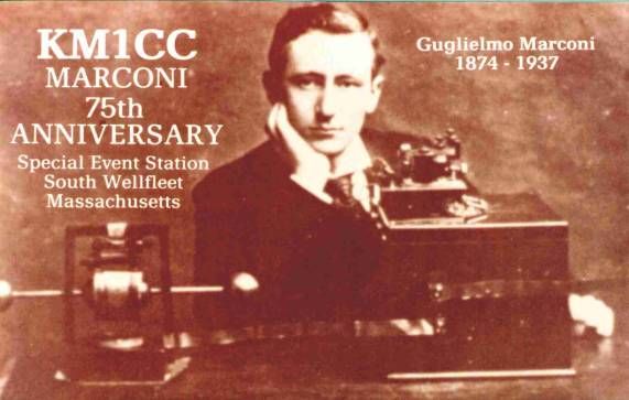
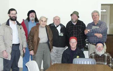
Members of Nashoba Valley ARC trekked to the Marconi Museum in Bedford NH on December 13 for a special group tour. Shown here are: (L-R) Ralph KD1SM, John KB1HDO, Ray Minichiello W1BC, museum curator, Dave N1MNX, Stan KD1LE, Gary K1YTS, Peter N1ZRG, Bob W1XP and behind the camera Peg (KB1HDO XYL). NVARC museum visit

Museum curator W1BC described the early equipment. Much of it was manufactured by the Marconi Company.

The museum is located in a Town-owned building in Bedford NH. Part of the lease arrangement requires improvements to the building and exterior painting. Nashoba Valley ARC members discussed a possible work party to help with improvements in the spring.

Nashoba Valley ARC Signal, January 2004. Photo courtesy KD1LE

Possible Blackouts Today (expired)

Freeze strains Northeast power grid
Report: Lethal temperatures kill 5 in Michigan
Friday, January 16, 2004 Posted: 9:33 AM EST (1433 GMT)

FORECAST WIND CHILLS
For Friday morning:
Caribou, Maine: Minus 45 F
Portland, Maine: Minus 35 F
Boston, Massachusetts: Minus 40 F
New York: Minus 25 F
Source: CNN

BOSTON, Massachusetts (CNN) — Temperatures remained below zero across New England on Friday morning after plunging to near record lows, straining power grids and bringing life to a near standstill in some places.

Officials asked residents to conserve energy voluntarily or face rolling blackouts.

The Midwest also is enduring bone-rattling temperatures that proved fatal for five people in Michigan, The Associated Press reported.

Vermont Gov. James Douglas appeared live on the state’s largest television network to urge New England residents to save energy and help prevent rolling blackouts, which may be needed in an extreme circumstance.

ISO New England Inc., the company responsible for maintaining the region’s power grid, is preparing to shut off power to some customers Friday if necessary to keep the grid working.

But early Friday no blackouts had been reported.The weather has created high demand for electricity, and as a result some power generating plants ran out of natural gas Thursday and increased the burden on other plants, according to ISO New England.

Steve Costello, a spokesman for the Central Vermont Public Service Corp., said it would be a first for the region if rolling blackouts are needed.

“We’ve never had to resort to that to maintain the stability of the system,” Costello said. “But there has been very, very high demand in New England today.”

CNN weather forecaster Galen Crader predicts the subfreezing temperatures will remain through the middle of next week.

Early Friday, the wind chill dropped to around 32 below zero in Boston and 17 below in New York, making it dangerous to expose any part of the body to the frigid air.

“These values can produce frostbite in just 10 or 15 minutes,” a National Weather Service advisory said. “If you don’t have to travel or be outside late tonight or early tomorrow, then stay indoors.”

In Maine, where wind chills could dip to 50 below zero Friday morning, Gov. John Baldacci declared a state of emergency in hopes of convincing federal highway regulators to allow longer driving hours for truckers carrying fuel oil.

“These conditions threaten public health and safety and endanger public property if fuel oil cannot be delivered to Maine homes and businesses,” Baldacci’s declaration said.

In Boston, the temperature reached a high of minus 2 degrees Thursday. The city’s largest homeless shelter, which provides 700 beds, has been packed.

But one woman on a Boston street said New Englanders know how to deal with bitterly cold weather:

“Dress in layers, keep moving and just try to have that old, good New England character,” she said.

Water used to douse a house fire in Oswego, New York, quickly became icicles in the bitter cold.
Business was off Thursday at a Waffle House restaurant in Tewksbury, Massachusetts, said cook Sandra Starke. “It’s awful, very cold,” she said. “We just got a dusting [of snow], but it’s so cold nobody wants to come out.”

New Hampshire’s Mount Washington Observatory, which boasts of having “the world’s worst weather,” recorded temperatures as low as 43 degrees below zero early Friday, coming close to the state’s all-time low temperature of minus 47.

Thursday evening, the observatory reported a wind chill of 97 below zero, with a combination of wind speeds gusting at 92 mph and an outside air temperature of minus 39.

“It’s actually very wonderful to be up here, to just be able to experience the weather extremes here that Mother Nature throws at you,” meteorologist Tim Markle said from a weather station on the mountain. “A lot of people don’t like the cold, but we’re loving it up here.”

CNN’s Laura Bernardini, Thom Patterson and Adaora Udoji contributed to this report.

Severe Cold, Wind & Ocean Effect Snow Coordination Message #2 (expired)

SKYWARN Logo
Hello to all…

….Wind Advisory Continues Through 6 PM Today over Cape Cod and the
Islands, the Greater Boston Metro Area, the Blue Hills Region, the higher
terrain of Worcester County and Block Island RI…
….Winter WX Advisory Posted for Outer Cape Cod for Ocean Effect Snow….
….Wind Chill Warning Continues Through Late Morning….
….Spotters are asked to report any wind damage to NWS Taunton. SKYWARN
Self-Activation May Be Needed if Wind Damage were widespread enough and
ARES/RACES Groups Should Monitor as any power outages that are widespread
enough coupled with the severe cold could result in activation for these
groups. Consult local ARES/RACES Leadership….

A Wind Advisory continues through 6 PM today over Cape Cod and the Islands,
the Boston Metro area, the Blue Hills region and the higher terrain of
Worcester County and Block Island RI. Wind gusts of 45-55 MPH are possible
with sustained winds of 25-35 MPH. This would be enough to cause some tree
and power line damage. Please report any wind damage to NWS Taunton as
needed. If wind damage is widespread enough, SKYWARN Self-Activation may be
needed.

A Winter WX Advisory is posted for Outer Cape Cod for Ocean Effect Snow. 1-3
inches of snow could occur from snow squalls over the Cape. Please report
snowfall every 2″ and final amounts to NWS.

A Wind Chill Warning Continues through late this morning. Low temperatures
ranged from -1 to -20 across much of the region with brutally cold wind
chills of -25 to -45 with some lower wind chills in the higher elevations.
Please allow extra time to warm up your vehicle and bundle up accordingly as
this will continue to be an extremely cold day with moderation occurring
this weekend. Those that have thermometers can report their lowest
temperature reading via email to me. Do not phone the spotter line with this
information since its not on our reporting criteria sheet.

As stated previously, SKYWARN Self-Activation may be needed if wind damage
were to become widespread enough. If enough wind damage were to occur over
vulnerable locations or over a widespread area, it could prompt ARES/RACES
groups to become active. Please consult local ARES/RACES leadership as
needed.

This will be the last coordination message. A roundup of below zero
temperatures will be sent out either tonight or Saturday Morning. Below is
the Wind Chill Warning/Winter WX Advisory, Wind Advisory and Hazardous WX
Outlook from NWS Taunton:FLUS41 KBOX 161159
HWOBOX

HAZARDOUS WEATHER OUTLOOK
NATIONAL WEATHER SERVICE TAUNTON MA
658 AM EST FRI JAN 16 2004

CTZ002>004-MAZ002>024-026-NHZ011-012-015-RIZ001>008-171159-
BARNSTABLE MA-BLOCK ISLAND RI-BRISTOL RI-CENTRAL MIDDLESEX MA-
CHESHIRE NH-DUKES MA-EASTERN ESSEX MA-EASTERN FRANKLIN MA-
EASTERN HAMPDEN MA-EASTERN HAMPSHIRE MA-EASTERN HILLSBOROUGH NH-
EASTERN KENT RI-EASTERN NORFOLK MA-EASTERN PLYMOUTH MA-HARTFORD CT-
NANTUCKET MA-NEWPORT RI-NORTHERN BRISTOL MA-NORTHERN WORCESTER MA-
NORTHWEST MIDDLESEX MA-NORTHWEST PROVIDENCE RI-
SOUTHEAST MIDDLESEX MA-SOUTHEAST PROVIDENCE RI-SOUTHERN BRISTOL MA-
SOUTHERN PLYMOUTH MA-SOUTHERN WORCESTER MA-SUFFOLK MA-TOLLAND CT-
WASHINGTON RI-WESTERN AND CENTRAL HILLSBOROUGH NH-WESTERN ESSEX MA-
WESTERN FRANKLIN MA-WESTERN HAMPDEN MA-WESTERN HAMPSHIRE MA-
WESTERN KENT RI-WESTERN NORFOLK MA-WESTERN PLYMOUTH MA-WINDHAM CT-
658 AM EST FRI JAN 16 2004

.DAY ONE…
WIND CHILL WARNINGS CONTINUE THROUGH ABOUT 10 AM FOR THE ENTIRE
FORECAST AREA THEN WILL PROBABLY BE DOWNGRADED TO THE LESS
THREATENING ADVISORY DURING MIDDAY. A WINTER WEATHER ADVISORY FOR THE
OUTER CAPE THIS MORNING IS FOR A COMBINATION OF SQUALLS…BLOWING AND
DRIFTING SNOW. A WIND ADVISORY CONTINUES THROUGH TONIGHT FOR SELECT
EXPOSURES ALONG THE SOUTH COAST…WORCESTER AND BOSTON FOR OCCASIONAL
SUSTAINED WINDS OVER 30 MPH WITH GUSTS 45 TO 55 MPH. PLEASE SEE THE
TWO PRIMARY STATEMENTS THAT REFERENCE DETAILS.

HARBOR ICE WILL CONTINUE TO EXPAND RAPIDLY THROUGH TONIGHT DESPITE
THE STEADY OR RISING TEMPERATURE TREND THAT BEGINS AROUND 8 AM THIS
MORNING AND CONTINUES THROUGH SATURDAY MID AFTERNOON.

THE AFTERMATH OF COLD RELATED ISSUES MAY CONTINUE WELL INTO NEXT WEEK
INCLUDING FROST HEAVES IN ROAD BEDS… AND ALSO EVENTUAL DEEP
PENETRATION OF FROST IN NON SNOWCOVERED AREAS OF THE I 95 CORRIDOR.

GALES CONTINUE ON THE COASTAL WATERS THROUGH TONIGHT.

.DAYS TWO THROUGH SEVEN…
THE ARCTIC AIRMASS WILL MODERATE THIS WEEKEND.

SNOW IS EXPECTED SUNDAY…RIGHT NOW NOT A BIG STORM BUT THIS NEEDS TO
BE WATCHED A BIT FOR A 1 TO 6 INCH ACCUMULATION…THAT MAY IMPACT
TRAVEL SAFETY CONDITIONS SUNDAY AFTERNOON. IT MAY BE WARM ENOUGH FOR
RAIN ON THE SOUTH COAST.

MUCH COLDER AIR WILL RETURN EARLY OR MIDDLE PART OF NEXT WEEK WITH
SUBZERO TEMPERATURES.

.SPOTTER CALL TO ACTION STATEMENT…
SPOTTER REPORTS ARE REQUESTED THURSDAY FOR SNOWFALL AMOUNTS 2 INCHES
AND GREATER.

$$

DRAG

WWUS41 KBOX 160909
WSWBOX

URGENT – WINTER WEATHER MESSAGE
NATIONAL WEATHER SERVICE TAUNTON MA
409 AM EST FRI JAN 16 2004

…DANGEROUSLY COLD WIND CHILL VALUES BETWEEN 25 AND 40 BELOW ZERO
WILL CONTINUE THROUGH 10 AM THEN EASE TO LESS THREATENING LEVELS
DURING MIDDAY…

.THE COLDEST WIND DRIVEN AIRMASS TO STRIKE OUR REGION SINCE CHRISTMAS
1980 HAS ALSO ESTABLISHED NEW RECORDS FOR THIS DATE IN BOSTON AND
PROVIDENCE. IT WILL SOON EASE ITS FRIGID GRIP ON OUR AREA…STARTING
AROUND 10 AM. HOWEVER…UNTIL THEN…FROSTBITE CAN STILL OCCUR TO
EXPOSED FLESH IN JUST 10 MINUTES THIS MORNING WITH THESE CONDITIONS!
IF YOU MUST VENTURE OUTDOORS…DRESS IN MANY LAYERS TO PROTECT
YOURSELF FROM THESE LIFE THREATENING CONDITIONS.

MAZ023-024-161515-
DUKES MA-NANTUCKET MA-
409 AM EST FRI JAN 16 2004

…WIND CHILL WARNING THIS MORNING FOR NANTUCKET AND MARTHAS
VINEYARD…

NORTHWEST WINDS OF 30 TO 40 MPH THIS MORNING COMBINED WITH ZERO AND
SUBZERO TEMPERATURES WILL CONTINUE CHILL VALUES IN THE 25 TO 40
BELOW ZERO RANGE. THEN THE SLOWLY RISING TEMPERATURES AFTER 10 AM
WILL ALLOW THE CHILL FACTOR TO SLOWLY DECREASE. HOWEVER…FOR MOST OF
THIS MORNING…THE FRIGID CHILL VALUES WILL MAKE IT DANGEROUS TO BE
OUTSIDE FOR MORE THAN A FEW MINUTES AT A TIME WITH PROPER PROTECTION.
EXPOSED SKIN MAY FREEZE IN AS LITTLE AS 10 MINUTES.

IF YOU MUST GO OUTDOORS…COVER ANY EXPOSED SKIN. WEAR A HAT…
MITTENS OR GLOVES…AND SEVERAL LAYERS OF LOOSE FITTING CLOTHING.
STAY TUNED TO NOAA WEATHER RADIO…OR YOUR FAVORITE MEDIA OUTLET…
FOR LATER INFORMATION.

$$

MAZ022-161515-
BARNSTABLE MA-
409 AM EST FRI JAN 16 2004

…WINTER WEATHER ADVISORY FOR OUTER CAPE COD THIS MORNING…
…WIND CHILL WARNING ALL OF CAPE COD THIS MORNING…

BANDS OF SNOW SHOWERS WILL DEPOSIT 1 TO 3 INCHES OF SNOW THIS MORNING
ON PARTS OF THE OUTER CAPE. THE STRONG WIND WILL CAUSE BLOWING AND
DRIFTING OF ANY SNOW THAT TRIES TO ACCUMULATE IN THIS ARCTIC
OUTBREAK.

IN ADDITION…NORTHWEST WINDS OF 30 TO 40 MPH THIS MORNING COMBINED
WITH ZERO AND SUBZERO TEMPERATURES WILL CONTINUE CHILL VALUES IN THE
25 TO 40 BELOW ZERO RANGE. THEN THE SLOWLY RISING TEMPERATURES AFTER
10 AM WILL ALLOW THE CHILL FACTOR TO SLOWLY DECREASE. HOWEVER…FOR
MOST OF THIS MORNING…THE FRIGID CHILL VALUES WILL MAKE IT DANGEROUS
TO BE OUTSIDE FOR MORE THAN A FEW MINUTES AT A TIME WITHOUT PROPER
PROTECTION. EXPOSED SKIN MAY FREEZE IN AS LITTLE AS 10 MINUTES.

IF YOU MUST GO OUTDOORS…COVER ANY EXPOSED SKIN. WEAR A HAT…
MITTENS OR GLOVES…AND SEVERAL LAYERS OF LOOSE FITTING CLOTHING.
STAY TUNED TO NOAA WEATHER RADIO…OR YOUR FAVORITE MEDIA OUTLET…
FOR LATER INFORMATION.

$$

MAZ002>010-014-026-NHZ011-012-015-161515-
CENTRAL MIDDLESEX MA-CHESHIRE NH-EASTERN ESSEX MA-
EASTERN FRANKLIN MA-EASTERN HAMPSHIRE MA-EASTERN HILLSBOROUGH NH-
NORTHERN WORCESTER MA-NORTHWEST MIDDLESEX MA-SOUTHEAST MIDDLESEX MA-
WESTERN AND CENTRAL HILLSBOROUGH NH-WESTERN ESSEX MA-
WESTERN FRANKLIN MA-WESTERN HAMPDEN MA-WESTERN HAMPSHIRE MA-
409 AM EST FRI JAN 16 2004

…WIND CHILL WARNING CONTINUES THIS MORNING…

NORTHERN MASSACHUSETTS AND SOUTHWEST NEW HAMPSHIRE WILL CONTINUE
EXPERIENCING SUSTAINED WINDS OF 20 TO 30 MPH WITH RIDGE TOP GUSTS OF
45 MPH THIS MORNING. THIS COMBINED WITH TEMPERATURES OF 5 TO 15 BELOW
ZERO WILL CONTINUE TO CREATE DANGEROUSLY COLD WIND CHILL VALUES OF
30 TO 40 DEGREES BELOW ZERO.

THE MOST SEVERE PORTION OF THE COLD WILL BEGIN EASING AFTER ABOUT
10 AM.

THESE FRIGID WIND CHILL VALUES…SELDOM OCCURRING IN RECENT TIMES
OVER OUR AREA…WILL MAKE IT DANGEROUS TO BE OUTSIDE. EXPOSED SKIN
MAY FREEZE IN AS LITTLE AS 10 MINUTES. IF YOU MUST GO OUTDOORS…
COVER ANY EXPOSED SKIN. WEAR A HAT…MITTENS OR GLOVES…AND SEVERAL
LAYERS OF LOOSE FITTING CLOTHING. STAY TUNED TO NOAA WEATHER RADIO…
OR YOUR FAVORITE MEDIA OUTLET…FOR LATER INFORMATION.

$$

CTZ002>004-MAZ011>013-015>021-RIZ001>008-161515-
BLOCK ISLAND RI-BRISTOL RI-EASTERN HAMPDEN MA-EASTERN KENT RI-
EASTERN NORFOLK MA-EASTERN PLYMOUTH MA-HARTFORD CT-NEWPORT RI-
NORTHERN BRISTOL MA-NORTHWEST PROVIDENCE RI-SOUTHEAST PROVIDENCE RI-
SOUTHERN BRISTOL MA-SOUTHERN PLYMOUTH MA-SOUTHERN WORCESTER MA-
SUFFOLK MA-TOLLAND CT-WASHINGTON RI-WESTERN KENT RI-
WESTERN NORFOLK MA-WESTERN PLYMOUTH MA-WINDHAM CT-
409 AM EST FRI JAN 16 2004

…WIND CHILL WARNING UNTIL 10 AM THIS MORNING…

AREAS OF NEW ENGLAND ALONG AND SOUTH OF THE MASSACHUSETTS TURNPIKE
WILL CONTINUE EXPERIENCING SUSTAINED WEST NORTHWEST WINDS OF 20 TO
30 MPH WITH GUSTS OF 45 MPH. THIS WIND COMBINED WITH SUBZERO
TEMPERATURES WILL CONTINUE TO CREATE DANGEROUSLY COLD WIND CHILL
VALUES OF AROUND 25 TO 35 BELOW ZERO IN RHODE ISLAND AND NORTHERN
CONNECTICUT AS WELL AS SOUTHEASTERN MASSACHUSETTS INCLUDING THE
BOSTON AREA.

THE MOST SEVERE PORTION OF THE COLD WILL BEGIN NOTICEABLY EASING
AFTER ABOUT 10 AM. HOWEVER STRONG WIND WILL CONTINUE ALL DAY.

THESE WIND CHILL VALUES WILL CONTINUE TO MAKE IT DANGEROUS TO BE
OUTSIDE FOR MORE THAN A FEW MINUTES AT A TIME…WITHOUT PROPER
PROTECTION. EXPOSED SKIN MAY FREEZE IN AS LITTLE AS 10 OR 15 MINUTES.
IF YOU MUST GO OUTDOORS…COVER ANY EXPOSED SKIN. WEAR A HAT…
MITTENS OR GLOVES…AND SEVERAL LAYERS OF LOOSE FITTING CLOTHING.
STAY TUNED TO NOAA WEATHER RADIO…OR YOUR FAVORITE MEDIA OUTLET…
FOR LATER INFORMATION.

$$

DRAG

Respectfully Submitted,

Robert Macedo (KD1CY)
ARES SKYWARN Coordinator
Southeast Massachusetts ARES District Emergency Coordinator
SEMARA ARES Emergency Coordinator
Pager #: (508) 354-3142
Home Phone #: (508) 994-1875 (After 6 PM)
Home/Data #: (508) 997-4503 (After 6 PM)
Work Phone #: 1-800-445-2588 Ext.: 72929 (8 AM-5 PM)
Email Address: rmacedo@rcn.com
http://users.rcn.com/rmacedo