New England Area   Ham - Electronic  Flea Market  ***  DATES  *** 2005 P 1 of 2

All events are Ham Radio/ Electronic related except ~_____~

*******************************************************************************

2005                                                    Contact          Source

~~~~~~~~~~~~~~~~~~~~~~~~~~~~~~~~~~~~~~~~~~~~~~~~~~~~~~~~~~~~~~~~~~~~~~~~~~~~~~~

2,3 April Timonium MD GBARC @FG 6AM                             800 HAM FEST F
2,3 April Watertown MA Photographica ~photo~            Ed Shaw 617 965 0807  +
3 April Framingham MA  FARA @Walsh Sch $5@9 $20/T     Bev N1LOO 508 626 2012 F+
9 Ap Londonderry NH IRS @Lions Club $10@6 $3@8        Paul K1NL 603 883 3308 F
9 April Montreal PQ MARC @RCLegion $4@8:30 $8@7:30  James VE2VE 514 697 7205 W
9 Ap Norwich CT RANSON Auction @ Fire House         Gary WT1SND 860 884 4218 A+
10 Ap Enfield CT VHF/UHF Conf @Radisson              Mark K1MAP 413 566 2445
10 Ap Henniker NH CVRC @Comm School B@8 S@7            Jim NS1E 603 428 7436 A
10 April Unionvale NY MtBARC                     Colleen KC2HUT 845 497 3687 A+
16 April S Portland ME PAWA @AmLegion                Roger N1XP 207 671 0671 W
17 April Cambridge MA          FLEA at MIT                 Nick 617 253 3776

                Third Sunday April thru October

23 Ap Nashua NH NE Antique RC $15/T@7 $2@9 @StStan's      Marty 603 938 5051 F
23 Ap Rochester NH GBRA 150 WakefieldSt @9AM $10/T Karen KB1KBE 207 698 1618  +
24 Ap Southington CT SARA @HS $5@9 $10@8:30 $18/T@6:30     Alex 860 214 3013 F
6,7 May Hopkinton NH HossTraders @FG x7 I89           Joe K1RQG 207 469 3492
9 May Whately MA FCARC @ElSc Monday $3@5PM $5/T      Walt W1ZPB 413 498 2729  +
14 May Goshen CT  SoBARC @ FG Rte 63 $3@8 $10/T@6     Lee K1LEE 860 435 0051  +
15 May Cambridge MA          FLEA at MIT                   Nick 617 253 3776
20-22 May Dayton OH
21 May E Greenbush NY EGARA @FireHS $5@8 $10/T@6    Betty N2POS 518 785 0727 F+
28 May WashTownship NJ BARA @WestwoodHS $5@8 $15@6     Jim K2ZO 201 664 6725 F
28 May Vernon CT NARC @Tolland Ag Ctr               Wayne N1GUS 860 487 1921 A
3-5 June Rochester NY $9@6AM+$10/sp                 Harold K2HC 585 424 7184 W
3 June Feeding Hills MA HCRA @CongCh $5/T@6:30PM     Dave KB1MU 413 596 6605
4 June Herman ME PSARC                             Roger KA!TKS 207 848 3846 A+
5 June Queens NY HoSARC @9A                      Stephen WB2KDG 718 898 5599 W+

~~~~~~~~~~~~~~~~~~~~~~~~~~~~~~~~~~~~~~~~~~~~~~~~~~~~~~~~~~~~~~~~~~~~~~~~~~~~~~~

LAST UPDATE 4-2-05 de W1GSL  http://www.swapfest.us                 P 1 of 2

*******************************************************************************

Additions/ Corrections via e-Mail   w1gsl@mit.edu   ***

Page 3 Electronic distribution only.  This page has the overflow if any    P3

from the paper version.

*******************************************************************************

2005                                                    Contact          Source

~~~~~~~~~~~~~~~~~~~~~~~~~~~~~~~~~~~~~~~~~~~~~~~~~~~~~~~~~~~~~~~~~~~~~~~~~~~~~~~

3 Dec Windsor CT VintgeR Museum @8AM @115 Pierson Ln       John 860 673 0518 W+

*******************************************************************************

2006                                                    Contact          Source

~~~~~~~~~~~~~~~~~~~~~~~~~~~~~~~~~~~~~~~~~~~~~~~~~~~~~~~~~~~~~~~~~~~~~~~~~~~~~~~

18 Mar Pomfret CT ECARA @CommSch Rt101+169 $2@8 $10/TPaul KE1LI 860 928 2456 T+
25-27 Aug Boxboro MA FEMARA NE Conv @HI              Mike K1TWF 978 250 1236 A+

*******************************************************************************

LAST UPDATE 6-2-05 de W1GSL                                             P 3

   List is normally updated twice a month - look for the latest version

Additions/ Corrections via Internet  w1gsl@mit.edu

                           US Mail  W1GSL POB 397082 MIT Br Cambridge MA 02139

(c)2005 W1GSL   http://www.swapfwst.us        SASE for updated copy as issued.

unlimited reproduction permitted in entirety

*******************************************************************************
This list has been posted... as a service of the individual home page

owners,  to the following WWW sites.
        http://flealist.senie.com/

        http://mit.edu/w1gsl/Public/ne-fleas

        http://www.k1ttt.net/flea.html

        http://www.connix.com/~wz1v/ne-fleas.html

        http://www.k1dwu.net/flealist.html

        http://www.mmra.org/~mmra/flealist.htm

        http://www.qsl.net/vhfnews/ne-fleas.html

        http://uhavax.hartford.edu/~newsvhf/ne-fleas.html
  List is normally updated twice a month - look for the latest version
Be sure to check for the latest version as updating is under the control

of the page owner.
* You can have the list e-mailed directly to you as it is updated.            *

* Just send a request to be added to the distribution to   w1gsl@mit.edu      *
                             73 Steve F

                                W1GSL
***********************************************************************

New England Area  Ham - Electronic  Flea Market  ***  DATES  ***     P4

Links to New England Hamfest Web Sites                (c) 2005 W1GSL

***********************************************************************

This section is only included in the electronic distribution.
Cambridge MA    Flea at MIT     http://www.swapfest.us
Hopkinton NH    Hosstraders     http://www.qsl.net/k1rqg/
Amherst MA      Mt. Tom ARC     http://www.mtara.org/hamfest/flea.html
Adams MA	N BerkshireARC	http://www.nobarc.org/hamfest
Boxborough MA   NE ARRL Conv    http://www.boxboro.org/
Framingham MA	FARA		http://www.fara.org/
Newton MA       Waltham ARA Auction    http://www.wara64.org/auction/
S Dartmouth MA  SEMARA          http://www.semara.org/flea/fleamkt.htm
Whately MA	FranklinCARC 	http://www.fcarc.org/flea.html
Enfield CT      VHF/UHF Conf    http://www.newsvhf.com
Newington CT 	NARL 		http://www.narl.net/1.htm
Southington CT  SARA            http://www.chetbacon.com/sara.htm
Wallingford CT  Nutmeg CT Conv  http://www.nutmeghamfest.com
Windsor CT      Vintage R Mus   http://www.NationalCommunicationsMuseum.org/
Lewiston ME     AARC		http://www.mainearrl.org/convent.htm         +
Portland ME     PAWA            http://www.qsl.net/pawa/fleamarket.html
Henniker NH     CVRC            http://www.qsl.net/k1bke/
Bergen NJ	BARA		http://www.bara.org/
Lake Placid NY  NNY ARA	 http://www.northnet.org/nnyham/hamfest_flyer2004.htm
Lindenhurst NY  ToB ARES 	http://www.tobares.org/hamfest.html
Long Island NY  LIMARC          http://www.limarc.org/fest.htm
Massapequa NY   GSB ARA	        http://www.gsbarc.org/
Queens NY       Hall of Science http://hosarc.org/hamfest.html               +
Rensselaer NY   E Greenbush ARA http://www.com-tech.org/EGARA.html
Rochester NY 	AWA		http://www.antiquewireless.org/
Rochester NY    RARA            http://www.rochesterhamfest.org/            +
Greenwich RI    Fidelity ARC    http://users.ids.net/~newsm/dates.html
Essex Junction VT   Burlington ARC  http://www.vtstetson.net/fest02.pdf
Milton VT       RANV VT Conv    http://www.ranv.org/milton.html
Montreal PQ     MARC            http://www.marc.qc.ca/fest/fest.html
Montreal PQ	WIARC		http://www.pubnix.net/wiarc/hamfest.htm
Montreal PQ     MS-SARC         http://www.ve2clm.ca/hamfesta.htm
Sorel-Tracy PQ  CRAS-T		http://www.hamfest.qc.ca/
St Therese PQ	CRALL		http://www.ve2crl.qc.ca/hamfest2002.htm
Halafax NS 	HARC            http://www.halifax-arc.org/
Canada          RAC List   http://rac.eton.ca/data/racfleas.taf?function=form
Phila. Area	VARA List	http://www.qsl.net/w2vtm/hamfest.html
USA             ARRL List       http://www.arrl.org/hamfests.html

 Terry Stader, KA8SCP writes:
 Ten SKYWARN training sessions have been scheduled throughout New England for 2005. (An eleventh will be added in July.) The information has been posted on the Eastern MA ARES web site.

 Bill O Hara, N1EY, writes:
 Bruce Pigott, KC1US, writes:
 Registration for the ARRL Amateur Radio Emergency Communications Level I on-line course (EC-001) opens Monday, April 04, 2005, at 1201 AM EST and will remain open until all available seats have been filled or through the April 9-10 weekend–whichever comes first. Class begins Friday, April 22. Thanks to our grant sponsors–the Corporation for National and Community Service and the United Technologies Corporation–the $45 registration fee paid upon enrollment will be reimbursed after successful completion of the course.
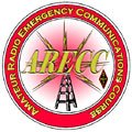 Registration for the ARRL Amateur Radio Emergency Communications Level I on-line course (EC-001) opens Monday, April 04, 2005, at 1201 AM EST and will remain open until all available seats have been filled or through the April 9-10 weekend–whichever comes first. Class begins Friday, April 22. Thanks to our grant sponsors–the Corporation for National and Community Service and the United Technologies Corporation–the $45 registration fee paid upon enrollment will be reimbursed after successful completion of the course.

 Phil Temples, K9HI writes:
 Bill O Hara, N1EY writes: